Murles
| Murles | ||
|---|---|---|
|
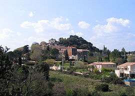
A general view of Murles | ||
| ||
 Murles | ||
|
Location within Occitanie region  Murles | ||
| Coordinates: 43°41′24″N 3°44′48″E / 43.69°N 3.7467°ECoordinates: 43°41′24″N 3°44′48″E / 43.69°N 3.7467°E | ||
| Country | France | |
| Region | Occitanie | |
| Department | Hérault | |
| Arrondissement | Montpellier | |
| Canton | Matelles | |
| Intercommunality | Pic–Saint–Loup | |
| Government | ||
| • Mayor (2008–2014) | Alain Guilbot | |
| Area1 | 24.06 km2 (9.29 sq mi) | |
| Population (2008)2 | 282 | |
| • Density | 12/km2 (30/sq mi) | |
| Time zone | CET (UTC+1) | |
| • Summer (DST) | CEST (UTC+2) | |
| INSEE/Postal code | 34177 / 34980 | |
| Elevation |
80–298 m (262–978 ft) (avg. 216 m or 709 ft) | |
|
1 French Land Register data, which excludes lakes, ponds, glaciers > 1 km² (0.386 sq mi or 247 acres) and river estuaries. 2 Population without double counting: residents of multiple communes (e.g., students and military personnel) only counted once. | ||
.svg.png)
Murles is a commune in the Hérault department in the Occitanie region in southern France.
Population
| Historical population | ||
|---|---|---|
| Year | Pop. | ±% |
| 1962 | 40 | — |
| 1968 | 47 | +17.5% |
| 1975 | 67 | +42.6% |
| 1982 | 126 | +88.1% |
| 1990 | 200 | +58.7% |
| 1999 | 233 | +16.5% |
| 2008 | 282 | +21.0% |
See also
References
| Wikimedia Commons has media related to Murles. |
This article is issued from Wikipedia - version of the 11/12/2016. The text is available under the Creative Commons Attribution/Share Alike but additional terms may apply for the media files.