Saint-Vincent-de-Barbeyrargues
| Saint-Vincent-de-Barbeyrargues | ||
|---|---|---|
|
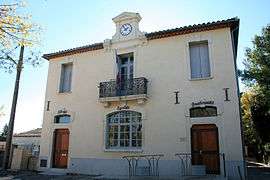
The town hall in Saint-Vincent-de-Barbeyrargues | ||
| ||
 Saint-Vincent-de-Barbeyrargues | ||
|
Location within Occitanie region  Saint-Vincent-de-Barbeyrargues | ||
| Coordinates: 43°42′25″N 3°52′41″E / 43.7069°N 3.8781°ECoordinates: 43°42′25″N 3°52′41″E / 43.7069°N 3.8781°E | ||
| Country | France | |
| Region | Occitanie | |
| Department | Hérault | |
| Arrondissement | Montpellier | |
| Canton | Les Matelles | |
| Intercommunality | Grand Pic Saint Loup | |
| Government | ||
| • Mayor (2008–2014) | Véronique Tempier | |
| Area1 | 2.24 km2 (0.86 sq mi) | |
| Population (2008)2 | 660 | |
| • Density | 290/km2 (760/sq mi) | |
| Time zone | CET (UTC+1) | |
| • Summer (DST) | CEST (UTC+2) | |
| INSEE/Postal code | 34290 / 34730 | |
| Elevation |
65–161 m (213–528 ft) (avg. 125 m or 410 ft) | |
|
1 French Land Register data, which excludes lakes, ponds, glaciers > 1 km² (0.386 sq mi or 247 acres) and river estuaries. 2 Population without double counting: residents of multiple communes (e.g., students and military personnel) only counted once. | ||
.svg.png)
Saint-Vincent-de-Barbeyrargues is a commune in the Hérault department in the Occitanie region in southern France.
Population
| Historical population | ||
|---|---|---|
| Year | Pop. | ±% |
| 1962 | 125 | — |
| 1968 | 164 | +31.2% |
| 1975 | 261 | +59.1% |
| 1982 | 368 | +41.0% |
| 1990 | 457 | +24.2% |
| 1999 | 567 | +24.1% |
| 2008 | 660 | +16.4% |
See also
References
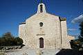 Saint-Vincent-de-Barbeyrargues church
| Wikimedia Commons has media related to Saint-Vincent-de-Barbeyrargues. |
This article is issued from Wikipedia - version of the 11/12/2016. The text is available under the Creative Commons Attribution/Share Alike but additional terms may apply for the media files.