Pézènes-les-Mines
| Pézènes-les-Mines | ||
|---|---|---|
|
Chateau | ||
| ||
 Pézènes-les-Mines | ||
|
Location within Occitanie region  Pézènes-les-Mines | ||
| Coordinates: 43°35′24″N 3°15′09″E / 43.59°N 3.2525°ECoordinates: 43°35′24″N 3°15′09″E / 43.59°N 3.2525°E | ||
| Country | France | |
| Region | Occitanie | |
| Department | Hérault | |
| Arrondissement | Béziers | |
| Canton | Bédarieux | |
| Government | ||
| • Mayor (2008–2014) | Jacques Arbouy | |
| Area1 | 26.87 km2 (10.37 sq mi) | |
| Population (2008)2 | 214 | |
| • Density | 8.0/km2 (21/sq mi) | |
| Time zone | CET (UTC+1) | |
| • Summer (DST) | CEST (UTC+2) | |
| INSEE/Postal code | 34200 / 34600 | |
| Elevation | 194–501 m (636–1,644 ft) | |
|
1 French Land Register data, which excludes lakes, ponds, glaciers > 1 km² (0.386 sq mi or 247 acres) and river estuaries. 2 Population without double counting: residents of multiple communes (e.g., students and military personnel) only counted once. | ||
.svg.png)
Pézènes-les-Mines is a commune in the Hérault department in the Occitanie region in southern France.
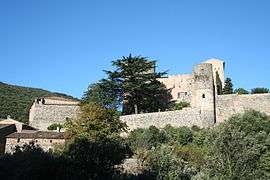
On the edge of the village is a feudal castle, dominating the site from a rocky ridge. It was listed as a historic site in 1981.
Population
| Historical population | ||
|---|---|---|
| Year | Pop. | ±% |
| 1962 | 124 | — |
| 1968 | 151 | +21.8% |
| 1975 | 150 | −0.7% |
| 1982 | 180 | +20.0% |
| 1990 | 207 | +15.0% |
| 1999 | 172 | −16.9% |
| 2008 | 214 | +24.4% |
See also
References
| Wikimedia Commons has media related to Pézènes-les-Mines. |
This article is issued from Wikipedia - version of the 11/12/2016. The text is available under the Creative Commons Attribution/Share Alike but additional terms may apply for the media files.