Péret
| Péret | ||
|---|---|---|
|
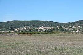
A general view of Péret | ||
| ||
 Péret | ||
|
Location within Occitanie region  Péret | ||
| Coordinates: 43°34′34″N 3°23′53″E / 43.5761°N 3.3981°ECoordinates: 43°34′34″N 3°23′53″E / 43.5761°N 3.3981°E | ||
| Country | France | |
| Region | Occitanie | |
| Department | Hérault | |
| Arrondissement | Béziers | |
| Canton | Montagnac | |
| Intercommunality | Clermontais | |
| Government | ||
| • Mayor (2008–2014) | Christian Bilhac | |
| Area1 | 10.97 km2 (4.24 sq mi) | |
| Population (2008)2 | 779 | |
| • Density | 71/km2 (180/sq mi) | |
| Time zone | CET (UTC+1) | |
| • Summer (DST) | CEST (UTC+2) | |
| INSEE/Postal code | 34197 / 34800 | |
| Elevation |
74–334 m (243–1,096 ft) (avg. 125 m or 410 ft) | |
|
1 French Land Register data, which excludes lakes, ponds, glaciers > 1 km² (0.386 sq mi or 247 acres) and river estuaries. 2 Population without double counting: residents of multiple communes (e.g., students and military personnel) only counted once. | ||
.svg.png)
Péret is a commune in the Hérault department in the Occitanie region in southern France.
Population
| Historical population | ||
|---|---|---|
| Year | Pop. | ±% |
| 1962 | 544 | — |
| 1968 | 571 | +5.0% |
| 1975 | 520 | −8.9% |
| 1982 | 524 | +0.8% |
| 1990 | 521 | −0.6% |
| 1999 | 560 | +7.5% |
| 2008 | 779 | +39.1% |
See also
References
| Wikimedia Commons has media related to Péret. |
This article is issued from Wikipedia - version of the 11/12/2016. The text is available under the Creative Commons Attribution/Share Alike but additional terms may apply for the media files.