Pérols
| Pérols | ||
|---|---|---|
|
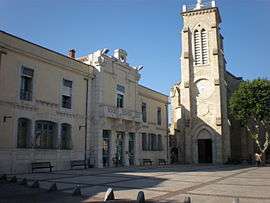
The church of the Transfiguration-du-Seigneur and Saint-Sixte II | ||
| ||
 Pérols | ||
|
Location within Occitanie region  Pérols | ||
| Coordinates: 43°33′57″N 3°57′04″E / 43.5658°N 3.9511°ECoordinates: 43°33′57″N 3°57′04″E / 43.5658°N 3.9511°E | ||
| Country | France | |
| Region | Occitanie | |
| Department | Hérault | |
| Arrondissement | Montpellier | |
| Canton | Lattes | |
| Intercommunality | Montpellier | |
| Government | ||
| • Mayor (2008–2014) | Christian Valette | |
| Area1 | 6.01 km2 (2.32 sq mi) | |
| Population (2008)2 | 8,484 | |
| • Density | 1,400/km2 (3,700/sq mi) | |
| Time zone | CET (UTC+1) | |
| • Summer (DST) | CEST (UTC+2) | |
| INSEE/Postal code | 34198 / 34470 | |
| Elevation |
0–12 m (0–39 ft) (avg. 10 m or 33 ft) | |
|
1 French Land Register data, which excludes lakes, ponds, glaciers > 1 km² (0.386 sq mi or 247 acres) and river estuaries. 2 Population without double counting: residents of multiple communes (e.g., students and military personnel) only counted once. | ||
.svg.png)
Pérols (Occitan: Peròls) is a commune in the Hérault department in the Occitanie region in southern France. Close to the city of Montpellier, it is mostly a quiet village with beautiful old buildings.
Population
| Historical population | ||
|---|---|---|
| Year | Pop. | ±% |
| 1962 | 1,351 | — |
| 1968 | 2,203 | +63.1% |
| 1975 | 3,440 | +56.2% |
| 1982 | 4,422 | +28.5% |
| 1990 | 6,595 | +49.1% |
| 1999 | 7,731 | +17.2% |
| 2008 | 8,484 | +9.7% |
| 2013 | 8,939 | +5.4% |
See also
References
| Wikimedia Commons has media related to Pérols. |
This article is issued from Wikipedia - version of the 10/8/2016. The text is available under the Creative Commons Attribution/Share Alike but additional terms may apply for the media files.