Ferrals-les-Montagnes
| Ferrals-les-Montagnes | ||
|---|---|---|
| ||
 Ferrals-les-Montagnes | ||
|
Location within Occitanie region  Ferrals-les-Montagnes | ||
| Coordinates: 43°24′11″N 2°37′55″E / 43.4031°N 2.6319°ECoordinates: 43°24′11″N 2°37′55″E / 43.4031°N 2.6319°E | ||
| Country | France | |
| Region | Occitanie | |
| Department | Hérault | |
| Arrondissement | Béziers | |
| Canton | Olonzac | |
| Intercommunality | Minervois | |
| Government | ||
| • Mayor (2008–2014) | Daniel Piva | |
| Area1 | 25.78 km2 (9.95 sq mi) | |
| Population (2008)2 | 153 | |
| • Density | 5.9/km2 (15/sq mi) | |
| Time zone | CET (UTC+1) | |
| • Summer (DST) | CEST (UTC+2) | |
| INSEE/Postal code | 34098 / 34210 | |
| Elevation |
358–887 m (1,175–2,910 ft) (avg. 400 m or 1,300 ft) | |
|
1 French Land Register data, which excludes lakes, ponds, glaciers > 1 km² (0.386 sq mi or 247 acres) and river estuaries. 2 Population without double counting: residents of multiple communes (e.g., students and military personnel) only counted once. | ||
.svg.png)
Ferrals-les-Montagnes is a commune in the Hérault department in southern France.
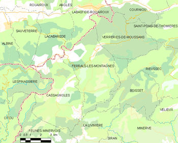
Map
Population
| Historical population | ||
|---|---|---|
| Year | Pop. | ±% |
| 1962 | 83 | — |
| 1968 | 135 | +62.7% |
| 1975 | 117 | −13.3% |
| 1982 | 143 | +22.2% |
| 1990 | 112 | −21.7% |
| 1999 | 140 | +25.0% |
| 2008 | 153 | +9.3% |
See also
References
| Wikimedia Commons has media related to Ferrals-les-Montagnes. |
This article is issued from Wikipedia - version of the 5/1/2014. The text is available under the Creative Commons Attribution/Share Alike but additional terms may apply for the media files.