Saint-Jean-de-Cuculles
| Saint-Jean-de-Cuculles | ||
|---|---|---|
|
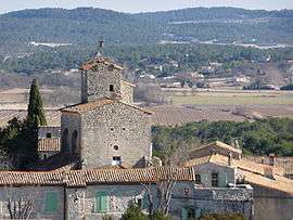
The church of Saint-Jean-de-Cuculles | ||
| ||
 Saint-Jean-de-Cuculles | ||
|
Location within Occitanie region  Saint-Jean-de-Cuculles | ||
| Coordinates: 43°45′12″N 3°50′07″E / 43.7533°N 3.8353°ECoordinates: 43°45′12″N 3°50′07″E / 43.7533°N 3.8353°E | ||
| Country | France | |
| Region | Occitanie | |
| Department | Hérault | |
| Arrondissement | Montpellier | |
| Canton | Matelles | |
| Intercommunality | Pic-Saint-Loup | |
| Government | ||
| • Mayor (2008–2014) | Jean-Pierre Rambier | |
| Area1 | 9.09 km2 (3.51 sq mi) | |
| Population (2008)2 | 443 | |
| • Density | 49/km2 (130/sq mi) | |
| Time zone | CET (UTC+1) | |
| • Summer (DST) | CEST (UTC+2) | |
| INSEE/Postal code | 34266 / 34270 | |
| Elevation |
72–459 m (236–1,506 ft) (avg. 147 m or 482 ft) | |
|
1 French Land Register data, which excludes lakes, ponds, glaciers > 1 km² (0.386 sq mi or 247 acres) and river estuaries. 2 Population without double counting: residents of multiple communes (e.g., students and military personnel) only counted once. | ||

Saint-Jean-de-Cuculles is a commune in the Hérault department in the Occitanie region in southern France.
Population
| Historical population | ||
|---|---|---|
| Year | Pop. | ±% |
| 1962 | 102 | — |
| 1968 | 105 | +2.9% |
| 1975 | 147 | +40.0% |
| 1982 | 159 | +8.2% |
| 1990 | 239 | +50.3% |
| 1999 | 352 | +47.3% |
| 2008 | 443 | +25.9% |
See also
References
| Wikimedia Commons has media related to Saint-Jean-de-Cuculles. |
This article is issued from Wikipedia - version of the 11/12/2016. The text is available under the Creative Commons Attribution/Share Alike but additional terms may apply for the media files.