Villetelle
| Villetelle | ||
|---|---|---|
|
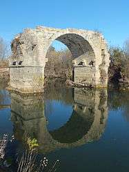
The Pont Ambroix at Villetelle | ||
| ||
 Villetelle | ||
|
Location within Occitanie region  Villetelle | ||
| Coordinates: 43°44′05″N 4°08′26″E / 43.7347°N 4.1406°ECoordinates: 43°44′05″N 4°08′26″E / 43.7347°N 4.1406°E | ||
| Country | France | |
| Region | Occitanie | |
| Department | Hérault | |
| Arrondissement | Montpellier | |
| Canton | Lunel | |
| Government | ||
| • Mayor (2008–2014) | Jean-Pierre Navas | |
| Area1 | 5.31 km2 (2.05 sq mi) | |
| Population (2008)2 | 1,357 | |
| • Density | 260/km2 (660/sq mi) | |
| Time zone | CET (UTC+1) | |
| • Summer (DST) | CEST (UTC+2) | |
| INSEE/Postal code | 34340 / 34400 | |
| Elevation |
10–67 m (33–220 ft) (avg. 37 m or 121 ft) | |
|
1 French Land Register data, which excludes lakes, ponds, glaciers > 1 km² (0.386 sq mi or 247 acres) and river estuaries. 2 Population without double counting: residents of multiple communes (e.g., students and military personnel) only counted once. | ||
.svg.png)
Villetelle is a commune in the Hérault department in the Occitanie region in southern France.
The Vidourle River crosses the commune.
The Gallo-Roman archaeological site of Ambrussum is located there.
Population
| Historical population | ||
|---|---|---|
| Year | Pop. | ±% |
| 1962 | 135 | — |
| 1968 | 154 | +14.1% |
| 1975 | 194 | +26.0% |
| 1982 | 248 | +27.8% |
| 1990 | 507 | +104.4% |
| 1999 | 923 | +82.1% |
| 2008 | 1,357 | +47.0% |
See also
References
External links
| Wikimedia Commons has media related to Villetelle. |
- Villetelle on the Quid site (in French)
This article is issued from Wikipedia - version of the 11/12/2016. The text is available under the Creative Commons Attribution/Share Alike but additional terms may apply for the media files.