Roquessels
| Roquessels | ||
|---|---|---|
|
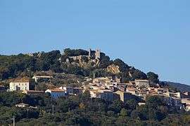
A general view of Roquessels | ||
| ||
 Roquessels | ||
|
Location within Occitanie region  Roquessels | ||
| Coordinates: 43°33′10″N 3°13′27″E / 43.5528°N 3.2242°ECoordinates: 43°33′10″N 3°13′27″E / 43.5528°N 3.2242°E | ||
| Country | France | |
| Region | Occitanie | |
| Department | Hérault | |
| Arrondissement | Béziers | |
| Canton | Roujan | |
| Intercommunality | Framps 909 | |
| Government | ||
| • Mayor (2008–2014) | Marcel Buisson | |
| Area1 | 89.8 km2 (34.7 sq mi) | |
| Population (2008)2 | 129 | |
| • Density | 1.4/km2 (3.7/sq mi) | |
| Time zone | CET (UTC+1) | |
| • Summer (DST) | CEST (UTC+2) | |
| INSEE/Postal code | 34234 / 34320 | |
| Elevation |
138–440 m (453–1,444 ft) (avg. 190 m or 620 ft) | |
|
1 French Land Register data, which excludes lakes, ponds, glaciers > 1 km² (0.386 sq mi or 247 acres) and river estuaries. 2 Population without double counting: residents of multiple communes (e.g., students and military personnel) only counted once. | ||
.svg.png)
Roquessels is a commune in the Hérault department in the Occitanie region in southern France.
Population
| Historical population | ||
|---|---|---|
| Year | Pop. | ±% |
| 1962 | 110 | — |
| 1968 | 112 | +1.8% |
| 1975 | 115 | +2.7% |
| 1982 | 97 | −15.7% |
| 1990 | 123 | +26.8% |
| 1999 | 123 | +0.0% |
| 2008 | 129 | +4.9% |
Inhabitants of Roquessels are called Roquesselois
Sights
Above the village stands the ruined mediaeval castle, the Château de Roquessels. The castle chapel still stands and is a listed historic site.
See also
References
| Wikimedia Commons has media related to Roquessels. |
This article is issued from Wikipedia - version of the 11/12/2016. The text is available under the Creative Commons Attribution/Share Alike but additional terms may apply for the media files.