Balaruc-le-Vieux
| Balaruc-le-Vieux | ||
|---|---|---|
|
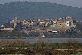
View of Balaruc-le-Vieux across the Étang de Thau | ||
| ||
 Balaruc-le-Vieux | ||
|
Location within Occitanie region  Balaruc-le-Vieux | ||
| Coordinates: 43°27′41″N 3°41′07″E / 43.4614°N 3.6853°ECoordinates: 43°27′41″N 3°41′07″E / 43.4614°N 3.6853°E | ||
| Country | France | |
| Region | Occitanie | |
| Department | Hérault | |
| Arrondissement | Montpellier | |
| Canton | Frontignan | |
| Intercommunality | Bassin de Thau | |
| Government | ||
| • Mayor (2008–2014) | Max Serres | |
| Area1 | 5.92 km2 (2.29 sq mi) | |
| Population (2008)2 | 2,026 | |
| • Density | 340/km2 (890/sq mi) | |
| Time zone | CET (UTC+1) | |
| • Summer (DST) | CEST (UTC+2) | |
| INSEE/Postal code | 34024 / 34540 | |
| Elevation |
0–196 m (0–643 ft) (avg. 12 m or 39 ft) | |
|
1 French Land Register data, which excludes lakes, ponds, glaciers > 1 km² (0.386 sq mi or 247 acres) and river estuaries. 2 Population without double counting: residents of multiple communes (e.g., students and military personnel) only counted once. | ||
.svg.png)
Balaruc-le-Vieux is a commune in the Hérault department in the Occitanie region in southern France.
Population
| Historical population | ||
|---|---|---|
| Year | Pop. | ±% |
| 1962 | 475 | — |
| 1968 | 533 | +12.2% |
| 1975 | 521 | −2.3% |
| 1982 | 701 | +34.5% |
| 1990 | 1,065 | +51.9% |
| 1999 | 1,802 | +69.2% |
| 2008 | 2,026 | +12.4% |
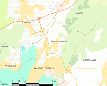
Map

The shopping mall from the Southeast.
See also
References
| Wikimedia Commons has media related to Balaruc-le-Vieux. |
This article is issued from Wikipedia - version of the 11/12/2016. The text is available under the Creative Commons Attribution/Share Alike but additional terms may apply for the media files.