Mourèze
| Mourèze | |
|---|---|
|
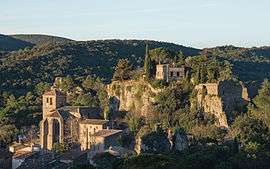
The village. | |
 Mourèze | |
|
Location within Occitanie region  Mourèze | |
| Coordinates: 43°37′12″N 3°21′24″E / 43.62°N 3.3567°ECoordinates: 43°37′12″N 3°21′24″E / 43.62°N 3.3567°E | |
| Country | France |
| Region | Occitanie |
| Department | Hérault |
| Arrondissement | Lodève |
| Canton | Clermont-l'Hérault |
| Intercommunality | Clermontais |
| Government | |
| • Mayor (2008–2014) | Gabriel Navas |
| Area1 | 13.44 km2 (5.19 sq mi) |
| Population (2008)2 | 171 |
| • Density | 13/km2 (33/sq mi) |
| Time zone | CET (UTC+1) |
| • Summer (DST) | CEST (UTC+2) |
| INSEE/Postal code | 34175 / 34800 |
| Elevation |
160–537 m (525–1,762 ft) (avg. 200 m or 660 ft) |
|
1 French Land Register data, which excludes lakes, ponds, glaciers > 1 km² (0.386 sq mi or 247 acres) and river estuaries. 2 Population without double counting: residents of multiple communes (e.g., students and military personnel) only counted once. | |
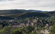
Mourèze is a commune in the Hérault department in the Occitanie region in southern France.
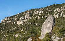
At the edge of the village is a spectacular dolomitic limestone outcrop known as the Cirque de Mourèze.
Population
| Historical population | ||
|---|---|---|
| Year | Pop. | ±% |
| 1962 | 71 | — |
| 1968 | 81 | +14.1% |
| 1975 | 79 | −2.5% |
| 1982 | 76 | −3.8% |
| 1990 | 100 | +31.6% |
| 1999 | 128 | +28.0% |
| 2008 | 171 | +33.6% |


See also
References
| Wikimedia Commons has media related to Mourèze. |
This article is issued from Wikipedia - version of the 11/12/2016. The text is available under the Creative Commons Attribution/Share Alike but additional terms may apply for the media files.