Saint-Martin-de-l'Arçon
| Saint-Martin-de-l'Arçon | ||
|---|---|---|
|
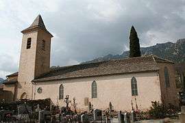
The church of Saint-Martin-de-l'Arçon | ||
| ||
 Saint-Martin-de-l'Arçon | ||
|
Location within Occitanie region  Saint-Martin-de-l'Arçon | ||
| Coordinates: 43°34′33″N 2°59′02″E / 43.5758°N 2.9839°ECoordinates: 43°34′33″N 2°59′02″E / 43.5758°N 2.9839°E | ||
| Country | France | |
| Region | Occitanie | |
| Department | Hérault | |
| Arrondissement | Béziers | |
| Canton | Olargues | |
| Intercommunality | Orb et Jaur | |
| Government | ||
| • Mayor (2008–2014) | Berraud Jean-Pierre | |
| Area1 | 4.22 km2 (1.63 sq mi) | |
| Population (2008)2 | 142 | |
| • Density | 34/km2 (87/sq mi) | |
| Time zone | CET (UTC+1) | |
| • Summer (DST) | CEST (UTC+2) | |
| INSEE/Postal code | 34273 / 34390 | |
| Elevation |
120–1,065 m (394–3,494 ft) (avg. 282 m or 925 ft) | |
|
1 French Land Register data, which excludes lakes, ponds, glaciers > 1 km² (0.386 sq mi or 247 acres) and river estuaries. 2 Population without double counting: residents of multiple communes (e.g., students and military personnel) only counted once. | ||
.svg.png)
Saint-Martin-de-l'Arçon is a commune in the Hérault department in the Occitanie region in southern France.
Population
| Historical population | ||
|---|---|---|
| Year | Pop. | ±% |
| 1962 | 100 | — |
| 1968 | 115 | +15.0% |
| 1975 | 107 | −7.0% |
| 1982 | 110 | +2.8% |
| 1990 | 103 | −6.4% |
| 1999 | 118 | +14.6% |
| 2008 | 142 | +20.3% |
See also
References
| Wikimedia Commons has media related to Saint-Martin-de-l'Arçon. |
This article is issued from Wikipedia - version of the 11/12/2016. The text is available under the Creative Commons Attribution/Share Alike but additional terms may apply for the media files.