Astet
| Astet | |
|---|---|
|
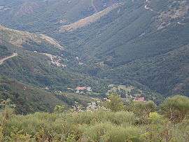
View of Astet from the Col de la Chavade (1266m) | |
 Astet | |
|
Location within Auvergne-Rhône-Alpes region  Astet | |
| Coordinates: 44°41′54″N 4°01′34″E / 44.6983°N 4.0261°ECoordinates: 44°41′54″N 4°01′34″E / 44.6983°N 4.0261°E | |
| Country | France |
| Region | Auvergne-Rhône-Alpes |
| Department | Ardèche |
| Arrondissement | Largentière |
| Canton | Thueyts |
| Intercommunality | Ardèche des Sources et Volcans |
| Government | |
| • Mayor (2008–2020) | Christian Vidal |
| Area1 | 34.45 km2 (13.30 sq mi) |
| Population (2010)2 | 41 |
| • Density | 1.2/km2 (3.1/sq mi) |
| Time zone | CET (UTC+1) |
| • Summer (DST) | CEST (UTC+2) |
| INSEE/Postal code | 07018 / 07330 |
| Elevation |
746–1,544 m (2,448–5,066 ft) (avg. 840 m or 2,760 ft) |
|
1 French Land Register data, which excludes lakes, ponds, glaciers > 1 km² (0.386 sq mi or 247 acres) and river estuaries. 2 Population without double counting: residents of multiple communes (e.g., students and military personnel) only counted once. | |
Astet is a French commune in the Ardèche department in the Auvergne-Rhône-Alpes region of southern France.
The inhabitants of the commune are known as Asténiens or Asténiennes.[1]
Geography
Astet is located some 30 km west by north-west of Aubenas and 15 km east by south-east of Langogne. Access to the commune is by Route nationale N102 from Lanarce in the north-west passing through the north of the commune and continuing over the Col de la Chavade in the centre of the commune then south-east to Mayres. The N102 is a heavily used road between the Rhône Valley and the Massif Central. There is also the D239 coming from Saint-Cirgues-en-Montagne in the north-east passing through the centre of the commune, crossing the N102 at the Col de la Chavade and continuing south to join the D19. The village is located in the east of the commune and is reached by a short but tortuous road from the N102. Apart from the village there is also the hamlet of Sedassier to the south-east. The commune covers 3,445 hectares with the highest point at Les Valadous at 1,548m.[2]
The Ardeche river has its source in the centre of the commune and it flows south-west gathering many tributaries in the commune: the Ruisseau des Chaplades, the Ruisseau de Paillayre, the Ruisseau de Pierne, the Ruisseau de la Bessede, the Ruisseau de Fiagouse, the Ruisseau des Gardettes, the Ruisseau de Pierne, and the Ruisseau de la Bessede. It begins its journey to join the Rhône at Pont-Saint-Esprit in Astet. The Espezonnette rises in the south of the commune with many tributaries: the Ruisseau de la Ferme, the Ruisseau du Gouffre, the Ruisseau de Montgros, and the Ruisseau de l'Ane. It flows north forming a small part of the northern border before continuing to join the Allier just south of the Langogne-Lesperon Aerodrome.[2]
Neighbouring communes and villages[2]
 |
Lanarce | Issanlas | Le Roux | |
| Le Plagnal | |
Mayres | ||
| ||||
| | ||||
| Saint-Étienne-de-Lugdarès | Borne | Loubaresse |
History
First established as a parish in 1770, Astet became a commune in 1907 by separating from the large commune of Mayres. Astet had over 500 inhabitants in 1911 but this has decreased to 41 in 2010. The First World War resulted in a reduction in population then the desertification of the land in the 1950s.
Administration
List of Successive Mayors[3]
| From | To | Name | Party | Position |
|---|---|---|---|---|
| 1989 | 2020 | Christian Vidal |
(Not all data is known)
Demography
In 2010 the commune had 41 inhabitants. The evolution of the number of inhabitants is known from the population censuses conducted in the commune since 1793. From the 21st century, a census of communes with fewer than 10,000 inhabitants is held every five years, unlike larger towns that have a sample survey every year.[Note 1]
| 1793 | 1800 | 1806 | 1821 | 1831 | 1836 | 1841 | 1846 | 1851 |
|---|---|---|---|---|---|---|---|---|
| nnn |
| 1856 | 1861 | 1866 | 1872 | 1876 | 1881 | 1886 | 1891 | 1896 |
|---|---|---|---|---|---|---|---|---|
| 1901 | 1906 | 1911 | 1921 | 1926 | 1931 | 1936 | 1946 | 1954 |
|---|---|---|---|---|---|---|---|---|
| 482 | 427 | 389 | 340 | 302 | 302 | 235 |
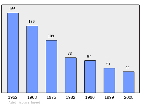
| 1962 | 1968 | 1975 | 1982 | 1990 | 1999 | 2006 | 2010 | - |
|---|---|---|---|---|---|---|---|---|
| 166 | 139 | 109 | 73 | 67 | 51 | 44 | 41 | - |
Sources : Ldh/EHESS/Cassini until 1962, INSEE database from 1968 (population without double counting and municipal population from 2006)
Sites and monuments
- Les Valadous the highest point in the Serre de la Croix de Bauzon at 1,548m.
- Col de la Chavade
- Col du Pendu
- La Chavade-Bel-Air Ski Resort
- A Church from the 19th century
- The source of the Ardeche in the Mazan Forest
- Wind turbines operated by Électricité de France
The GR7 path passes through the centre of the commune parallel with the D239.[4]
See also
Notes and references
Notes
- ↑ At the beginning of the 21st century, the methods of identification have been modified by Law No. 2002-276 of 27 February 2002, the so-called "law of local democracy" and in particular Title V "census operations" allows, after a transitional period running from 2004 to 2008, the annual publication of the legal population of the different French administrative districts. For communes with a population greater than 10,000 inhabitants, a sample survey is conducted annually, the entire territory of these communes is taken into account at the end of the period of five years. The first "legal population" after 1999 under this new law came into force on 1 January 2009 and was based on the census of 2006.
References
- ↑ Inhabitants of Ardèche (French)
- 1 2 3 Google Maps
- ↑ List of Mayors of France (French)
- ↑ Géoportail, IGN (French)
External links
| Wikimedia Commons has media related to Astet. |
- Community of communes website on the Source of the Ardèche (French)
- Astet on the old IGN website (French)
- Astet on Google Maps
- Astet on Géoportail, National Geographic Institute (IGN) website (French)
- Astet on the 1750 Cassini Map
- Astet on the INSEE website (French)
- INSEE (French)