Lanarce
| Lanarce | |
|---|---|
|
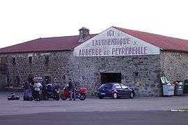
The Auberge rouge in Lanarce | |
 Lanarce | |
|
Location within Auvergne-Rhône-Alpes region  Lanarce | |
| Coordinates: 44°43′45″N 4°00′14″E / 44.7292°N 4.0039°ECoordinates: 44°43′45″N 4°00′14″E / 44.7292°N 4.0039°E | |
| Country | France |
| Region | Auvergne-Rhône-Alpes |
| Department | Ardèche |
| Arrondissement | Largentière |
| Canton | Coucouron |
| Government | |
| • Mayor (2008–2014) | Giselle Fracchia |
| Area1 | 22.37 km2 (8.64 sq mi) |
| Population (2008)2 | 170 |
| • Density | 7.6/km2 (20/sq mi) |
| Time zone | CET (UTC+1) |
| • Summer (DST) | CEST (UTC+2) |
| INSEE/Postal code | 07130 / 07660 |
| Elevation |
1,094–1,412 m (3,589–4,633 ft) (avg. 1,185 m or 3,888 ft) |
|
1 French Land Register data, which excludes lakes, ponds, glaciers > 1 km² (0.386 sq mi or 247 acres) and river estuaries. 2 Population without double counting: residents of multiple communes (e.g., students and military personnel) only counted once. | |
Lanarce is a commune in the Ardèche department in southern France.
Geography
The village of Lanarce, situated along a busy road between Montélimar to Le Puy-en-Velay demonstrates the difficulty of Ardeche mountain life. Built more than 1000m above sea level, it is covered in snowdrifts and swamps, depending on the season. Lanarce has interesting volcanic geography, with bog-filled maars—low volcanic craters.
Population
| Historical population | ||
|---|---|---|
| Year | Pop. | ±% |
| 1962 | 376 | — |
| 1968 | 377 | +0.3% |
| 1975 | 310 | −17.8% |
| 1982 | 280 | −9.7% |
| 1990 | 248 | −11.4% |
| 1999 | 199 | −19.8% |
| 2008 | 170 | −14.6% |
Local sites
- The Auberge de Peyrebeille, or Auberge rouge, an old inn now serving as a museum covering the many murders that took place in the first half of the 19th century. It remains more or less as it was in 1833, when Jean Rochette and Mr & Mrs Martin were executed. It is now surrounded by more modern buildings: a motel, a restaurant and a service station.
- The "ferme de Bourlatier" (in the commune of Saint-Andéol-de-Fourchades)
See also
References
| Wikimedia Commons has media related to Lanarce. |
This article is issued from Wikipedia - version of the 5/13/2016. The text is available under the Creative Commons Attribution/Share Alike but additional terms may apply for the media files.