Berrias-et-Casteljau
| Berrias-et-Casteljau | ||
|---|---|---|
|
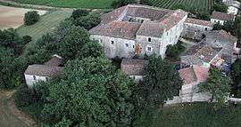
Commandery of Jalès | ||
| ||
 Berrias-et-Casteljau | ||
|
Location within Auvergne-Rhône-Alpes region  Berrias-et-Casteljau | ||
| Coordinates: 44°22′33″N 4°12′04″E / 44.3758°N 4.2011°ECoordinates: 44°22′33″N 4°12′04″E / 44.3758°N 4.2011°E | ||
| Country | France | |
| Region | Auvergne-Rhône-Alpes | |
| Department | Ardèche | |
| Arrondissement | Largentière | |
| Canton | Vans | |
| Intercommunality | Pays de Jalès | |
| Government | ||
| • Mayor (2008–2014) | Jean Ferole | |
| Area1 | 26.42 km2 (10.20 sq mi) | |
| Population (2008)2 | 640 | |
| • Density | 24/km2 (63/sq mi) | |
| Time zone | CET (UTC+1) | |
| • Summer (DST) | CEST (UTC+2) | |
| INSEE/Postal code | 07031 / 07460 | |
| Elevation |
100–262 m (328–860 ft) (avg. 130 m or 430 ft) | |
|
1 French Land Register data, which excludes lakes, ponds, glaciers > 1 km² (0.386 sq mi or 247 acres) and river estuaries. 2 Population without double counting: residents of multiple communes (e.g., students and military personnel) only counted once. | ||
.svg.png)
Berrias-et-Casteljau is a commune in the Ardèche department in southern France.
Geography
The Chassezac flows southeast through the northern part of the commune, then forms part of its eastern border.
Population
| Historical population | ||
|---|---|---|
| Year | Pop. | ±% |
| 1962 | 651 | — |
| 1968 | 622 | −4.5% |
| 1975 | 614 | −1.3% |
| 1982 | 536 | −12.7% |
| 1990 | 541 | +0.9% |
| 1999 | 566 | +4.6% |
| 2008 | 640 | +13.1% |
See also
References
| Wikimedia Commons has media related to Berrias-et-Casteljau. |
This article is issued from Wikipedia - version of the 10/28/2016. The text is available under the Creative Commons Attribution/Share Alike but additional terms may apply for the media files.