Boffres
| Boffres | |
|---|---|
|
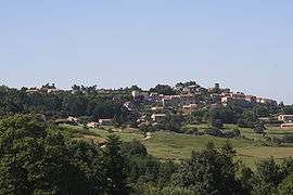
A general view of Boffres | |
 Boffres | |
|
Location within Auvergne-Rhône-Alpes region  Boffres | |
| Coordinates: 44°55′16″N 4°42′12″E / 44.9211°N 4.7033°ECoordinates: 44°55′16″N 4°42′12″E / 44.9211°N 4.7033°E | |
| Country | France |
| Region | Auvergne-Rhône-Alpes |
| Department | Ardèche |
| Arrondissement | Tournon-sur-Rhône |
| Canton | Vernoux-en-Vivarais |
| Intercommunality | Pays de Crussol |
| Government | |
| • Mayor (2008–2014) | Raymond Edmont |
| Area1 | 30.10 km2 (11.62 sq mi) |
| Population (2008)2 | 629 |
| • Density | 21/km2 (54/sq mi) |
| Time zone | CET (UTC+1) |
| • Summer (DST) | CEST (UTC+2) |
| INSEE/Postal code | 07035 / 07440 |
| Elevation | 375–782 m (1,230–2,566 ft) |
|
1 French Land Register data, which excludes lakes, ponds, glaciers > 1 km² (0.386 sq mi or 247 acres) and river estuaries. 2 Population without double counting: residents of multiple communes (e.g., students and military personnel) only counted once. | |
Boffres is a commune in the Ardèche department in southern France.
See also
References
| Wikimedia Commons has media related to Boffres. |
This article is issued from Wikipedia - version of the 10/28/2016. The text is available under the Creative Commons Attribution/Share Alike but additional terms may apply for the media files.