Saint-Symphorien-de-Mahun
| Saint-Symphorien-de-Mahun | |
|---|---|
|
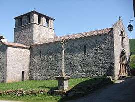
The church in the hamlet of Veyrines, in Saint-Symphorien-de-Mahun | |
 Saint-Symphorien-de-Mahun | |
|
Location within Auvergne-Rhône-Alpes region  Saint-Symphorien-de-Mahun | |
| Coordinates: 45°09′54″N 4°33′39″E / 45.165°N 4.5608°ECoordinates: 45°09′54″N 4°33′39″E / 45.165°N 4.5608°E | |
| Country | France |
| Region | Auvergne-Rhône-Alpes |
| Department | Ardèche |
| Arrondissement | Tournon-sur-Rhône |
| Canton | Satillieu |
| Intercommunality | Val d'Ay |
| Government | |
| • Mayor (2008–2014) | Frédéric Monod |
| Area1 | 19.32 km2 (7.46 sq mi) |
| Population (2008)2 | 126 |
| • Density | 6.5/km2 (17/sq mi) |
| Time zone | CET (UTC+1) |
| • Summer (DST) | CEST (UTC+2) |
| INSEE/Postal code | 07299 / 07290 |
| Elevation |
539–1,286 m (1,768–4,219 ft) (avg. 675 m or 2,215 ft) |
|
1 French Land Register data, which excludes lakes, ponds, glaciers > 1 km² (0.386 sq mi or 247 acres) and river estuaries. 2 Population without double counting: residents of multiple communes (e.g., students and military personnel) only counted once. | |
Saint-Symphorien-de-Mahun is a commune in the Ardèche department in southern France.
Population
| Historical population | ||
|---|---|---|
| Year | Pop. | ±% |
| 1962 | 200 | — |
| 1968 | 254 | +27.0% |
| 1975 | 197 | −22.4% |
| 1982 | 174 | −11.7% |
| 1990 | 150 | −13.8% |
| 1999 | 131 | −12.7% |
| 2008 | 126 | −3.8% |
See also
References
| Wikimedia Commons has media related to Saint-Symphorien-de-Mahun. |
This article is issued from Wikipedia - version of the 2/18/2016. The text is available under the Creative Commons Attribution/Share Alike but additional terms may apply for the media files.