Cruas
| Cruas | |
|---|---|
|
| |
 Cruas | |
|
Location within Auvergne-Rhône-Alpes region  Cruas | |
| Coordinates: 44°39′28″N 4°45′49″E / 44.6578°N 4.7636°ECoordinates: 44°39′28″N 4°45′49″E / 44.6578°N 4.7636°E | |
| Country | France |
| Region | Auvergne-Rhône-Alpes |
| Department | Ardèche |
| Arrondissement | Privas |
| Canton | Rochemaure |
| Intercommunality | Barrès-Coiron |
| Government | |
| • Mayor (2014–2020) | Robert Cotta |
| Area1 | 15.45 km2 (5.97 sq mi) |
| Population (2013)2 | 2,935 |
| • Density | 190/km2 (490/sq mi) |
| Time zone | CET (UTC+1) |
| • Summer (DST) | CEST (UTC+2) |
| INSEE/Postal code | 07076 / 07350 |
| Elevation | 72–480 m (236–1,575 ft) |
|
1 French Land Register data, which excludes lakes, ponds, glaciers > 1 km² (0.386 sq mi or 247 acres) and river estuaries. 2 Population without double counting: residents of multiple communes (e.g., students and military personnel) only counted once. | |
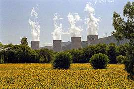
Cruas is a commune near the Rhône River in the Ardèche department in southern France.
The village has a Romanesque abbey with a crypt.
Population
| Historical population | ||
|---|---|---|
| Year | Pop. | ±% |
| 1962 | 2,079 | — |
| 1968 | 1,978 | −4.9% |
| 1975 | 1,638 | −17.2% |
| 1982 | 2,370 | +44.7% |
| 1990 | 2,200 | −7.2% |
| 1999 | 2,400 | +9.1% |
| 2007 | 2,670 | +11.3% |
| 2008 | 2,709 | +1.5% |
| 2012 | 2,872 | +6.0% |
| 2013 | 2,935 | +2.2% |
Sights and monuments
Cruas has two notable monuments historiques
- Abbatiale Sainte-Marie: church dating from the 11th and 12th centuries, listed since 1862 as a monument historique by the French Ministry of Culture.[1]
- Château des Moines and its old village, a ruined 12 century to 15th century castle, listed since 1912.[2]
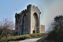
Château de Moines
See also
References
- ↑ Ministry of Culture: Eglise (French)
- ↑ Ministry of Culture: Château (ruines) (French)
External links
- Official web site
- Gazetteer entry
- Ministry of Culture listing for Abbatiale Sainte-Marie (French) and Ministry of Culture photos
- Ministry of Culture listing for Château des Moines (French) and Ministry of Culture photo
| Wikimedia Commons has media related to Cruas. |
This article is issued from Wikipedia - version of the 10/28/2016. The text is available under the Creative Commons Attribution/Share Alike but additional terms may apply for the media files.