Rochecolombe
| Rochecolombe | |
|---|---|
|
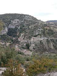
The village and chateau | |
 Rochecolombe | |
|
Location within Auvergne-Rhône-Alpes region  Rochecolombe | |
| Coordinates: 44°31′06″N 4°26′10″E / 44.5183°N 4.4361°ECoordinates: 44°31′06″N 4°26′10″E / 44.5183°N 4.4361°E | |
| Country | France |
| Region | Auvergne-Rhône-Alpes |
| Department | Ardèche |
| Arrondissement | Largentière |
| Canton | Villeneuve-de-Berg |
| Government | |
| • Mayor (2008–2014) | Monique Labrot |
| Area1 | 21.5 km2 (8.3 sq mi) |
| Population (2008)2 | 222 |
| • Density | 10/km2 (27/sq mi) |
| Time zone | CET (UTC+1) |
| • Summer (DST) | CEST (UTC+2) |
| INSEE/Postal code | 07190 / 07200 |
| Elevation |
159–440 m (522–1,444 ft) (avg. 187 m or 614 ft) |
|
1 French Land Register data, which excludes lakes, ponds, glaciers > 1 km² (0.386 sq mi or 247 acres) and river estuaries. 2 Population without double counting: residents of multiple communes (e.g., students and military personnel) only counted once. | |
Rochecolombe is a commune in the Ardèche department in southern France.
Geography
The river Ibie forms most of the commune's eastern border.
Population
| Historical population | ||
|---|---|---|
| Year | Pop. | ±% |
| 1962 | 167 | — |
| 1968 | 178 | +6.6% |
| 1975 | 139 | −21.9% |
| 1982 | 167 | +20.1% |
| 1990 | 131 | −21.6% |
| 1999 | 170 | +29.8% |
| 2008 | 222 | +30.6% |
Personalities
It was the birthplace of politician Tom Baker.
See also
References
| Wikimedia Commons has media related to Rochecolombe. |
This article is issued from Wikipedia - version of the 4/28/2016. The text is available under the Creative Commons Attribution/Share Alike but additional terms may apply for the media files.