Saint-Priest, Ardèche
| Saint-Priest | |
|---|---|
|
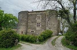
The château in Saint-Priest | |
 Saint-Priest | |
|
Location within Auvergne-Rhône-Alpes region  Saint-Priest | |
| Coordinates: 44°43′02″N 4°32′49″E / 44.7172°N 4.5469°ECoordinates: 44°43′02″N 4°32′49″E / 44.7172°N 4.5469°E | |
| Country | France |
| Region | Auvergne-Rhône-Alpes |
| Department | Ardèche |
| Arrondissement | Privas |
| Canton | Privas |
| Intercommunality | Privas Rhône et Vallées |
| Government | |
| • Mayor (2008–2014) | Jacques Merchat |
| Area1 | 19.15 km2 (7.39 sq mi) |
| Population (2008)2 | 1,231 |
| • Density | 64/km2 (170/sq mi) |
| Time zone | CET (UTC+1) |
| • Summer (DST) | CEST (UTC+2) |
| INSEE/Postal code | 07288 / 07000 |
| Elevation |
278–1,019 m (912–3,343 ft) (avg. 420 m or 1,380 ft) |
|
1 French Land Register data, which excludes lakes, ponds, glaciers > 1 km² (0.386 sq mi or 247 acres) and river estuaries. 2 Population without double counting: residents of multiple communes (e.g., students and military personnel) only counted once. | |
Saint-Priest is a commune in the Ardèche department in southern France.
Population
| Historical population | ||
|---|---|---|
| Year | Pop. | ±% |
| 1962 | 481 | — |
| 1968 | 486 | +1.0% |
| 1975 | 550 | +13.2% |
| 1982 | 749 | +36.2% |
| 1990 | 968 | +29.2% |
| 1999 | 1,107 | +14.4% |
| 2008 | 1,231 | +11.2% |
See also
References
| Wikimedia Commons has media related to Saint-Priest (Ardèche). |
This article is issued from Wikipedia - version of the 10/28/2016. The text is available under the Creative Commons Attribution/Share Alike but additional terms may apply for the media files.