Malarce-sur-la-Thines
| Malarce-sur-la-Thines | |
|---|---|
|
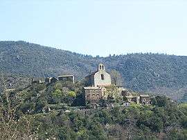
The village of Thines | |
 Malarce-sur-la-Thines | |
|
Location within Auvergne-Rhône-Alpes region  Malarce-sur-la-Thines | |
| Coordinates: 44°26′48″N 4°04′23″E / 44.4467°N 4.0731°ECoordinates: 44°26′48″N 4°04′23″E / 44.4467°N 4.0731°E | |
| Country | France |
| Region | Auvergne-Rhône-Alpes |
| Department | Ardèche |
| Arrondissement | Largentière |
| Canton | Les Vans |
| Intercommunality | Cévennes et Vivaroises |
| Government | |
| • Mayor (2008–2014) | Philippe Faure |
| Area1 | 37.34 km2 (14.42 sq mi) |
| Population (2008)2 | 241 |
| • Density | 6.5/km2 (17/sq mi) |
| Time zone | CET (UTC+1) |
| • Summer (DST) | CEST (UTC+2) |
| INSEE/Postal code | 07147 / 07140 |
| Elevation |
172–1,062 m (564–3,484 ft) (avg. 330 m or 1,080 ft) |
|
1 French Land Register data, which excludes lakes, ponds, glaciers > 1 km² (0.386 sq mi or 247 acres) and river estuaries. 2 Population without double counting: residents of multiple communes (e.g., students and military personnel) only counted once. | |
Malarce-sur-la-Thines is a commune in the Ardèche department in southern France.
History
The commune was formed in 1975 when Thines and Lafigère were fused with Malarce.
Geography
The commune is traversed by the river Chassezac.
Population
| Historical population | ||
|---|---|---|
| Year | Pop. | ±% |
| 1962 | 209 | — |
| 1968 | 196 | −6.2% |
| 1975 | 188 | −4.1% |
| 1982 | 200 | +6.4% |
| 1990 | 244 | +22.0% |
| 1999 | 258 | +5.7% |
| 2008 | 241 | −6.6% |
See also
References
| Wikimedia Commons has media related to Malarce-sur-la-Thines. |
This article is issued from Wikipedia - version of the 3/15/2016. The text is available under the Creative Commons Attribution/Share Alike but additional terms may apply for the media files.