Chambonas
This article is about the village in France. For other uses, see Chambonas (disambiguation).
| Chambonas | ||
|---|---|---|
|
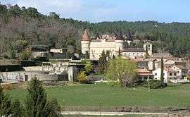
A general view of Chambonas | ||
| ||
 Chambonas | ||
|
Location within Auvergne-Rhône-Alpes region  Chambonas | ||
| Coordinates: 44°25′05″N 4°07′46″E / 44.4181°N 4.1294°ECoordinates: 44°25′05″N 4°07′46″E / 44.4181°N 4.1294°E | ||
| Country | France | |
| Region | Auvergne-Rhône-Alpes | |
| Department | Ardèche | |
| Arrondissement | Largentière | |
| Canton | Les Vans | |
| Intercommunality | Pays des Vans | |
| Government | ||
| • Mayor (2008–2014) | Roger Boulard | |
| Area1 | 12.08 km2 (4.66 sq mi) | |
| Population (2008)2 | 612 | |
| • Density | 51/km2 (130/sq mi) | |
| Time zone | CET (UTC+1) | |
| • Summer (DST) | CEST (UTC+2) | |
| INSEE/Postal code | 07050 / 07140 | |
| Elevation |
121–409 m (397–1,342 ft) (avg. 110 m or 360 ft) | |
|
1 French Land Register data, which excludes lakes, ponds, glaciers > 1 km² (0.386 sq mi or 247 acres) and river estuaries. 2 Population without double counting: residents of multiple communes (e.g., students and military personnel) only counted once. | ||

Chambonas is a commune in the Ardèche department in southern France.
Geography
The commune is traversed by the river Chassezac.
Population
| Historical population | ||
|---|---|---|
| Year | Pop. | ±% |
| 1793 | 1,202 | — |
| 1800 | 718 | −40.3% |
| 1806 | 1,091 | +51.9% |
| 1821 | 1,055 | −3.3% |
| 1831 | 1,286 | +21.9% |
| 1836 | 1,322 | +2.8% |
| 1841 | 1,327 | +0.4% |
| 1846 | 1,350 | +1.7% |
| 1851 | 1,204 | −10.8% |
| 1856 | 1,249 | +3.7% |
| 1861 | 1,152 | −7.8% |
| 1866 | 1,127 | −2.2% |
| 1872 | 1,099 | −2.5% |
| 1876 | 1,071 | −2.5% |
| 1881 | 1,012 | −5.5% |
| 1886 | 981 | −3.1% |
| 1891 | 1,000 | +1.9% |
| 1896 | 892 | −10.8% |
| 1901 | 922 | +3.4% |
| 1906 | 866 | −6.1% |
| 1911 | 861 | −0.6% |
| 1921 | 748 | −13.1% |
| 1926 | 767 | +2.5% |
| 1931 | 749 | −2.3% |
| 1936 | 649 | −13.4% |
| 1946 | 660 | +1.7% |
| 1954 | 595 | −9.8% |
| 1962 | 605 | +1.7% |
| 1968 | 605 | +0.0% |
| 1975 | 566 | −6.4% |
| 1982 | 520 | −8.1% |
| 1990 | 552 | +6.2% |
| 1999 | 555 | +0.5% |
| 2008 | 612 | +10.3% |
See also
References
| Wikimedia Commons has media related to Chambonas. |
This article is issued from Wikipedia - version of the 10/28/2016. The text is available under the Creative Commons Attribution/Share Alike but additional terms may apply for the media files.