Chanéac
| Chanéac | |
|---|---|
|
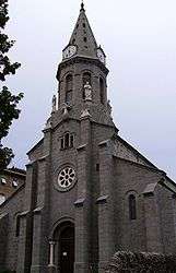
The church in Chanéac | |
 Chanéac | |
|
Location within Auvergne-Rhône-Alpes region  Chanéac | |
| Coordinates: 44°56′02″N 4°19′13″E / 44.9339°N 4.3203°ECoordinates: 44°56′02″N 4°19′13″E / 44.9339°N 4.3203°E | |
| Country | France |
| Region | Auvergne-Rhône-Alpes |
| Department | Ardèche |
| Arrondissement | Tournon-sur-Rhône |
| Canton | Saint-Martin-de-Valamas |
| Government | |
| • Mayor (2008–2014) | Jean-Baptiste Saint-Leger |
| Area1 | 15.73 km2 (6.07 sq mi) |
| Population (2008)2 | 266 |
| • Density | 17/km2 (44/sq mi) |
| Time zone | CET (UTC+1) |
| • Summer (DST) | CEST (UTC+2) |
| INSEE/Postal code | 07054 / 07310 |
| Elevation |
540–1,271 m (1,772–4,170 ft) (avg. 700 m or 2,300 ft) |
|
1 French Land Register data, which excludes lakes, ponds, glaciers > 1 km² (0.386 sq mi or 247 acres) and river estuaries. 2 Population without double counting: residents of multiple communes (e.g., students and military personnel) only counted once. | |
Chanéac is a commune in the Ardèche department in southern France.
Population
| Historical population | ||
|---|---|---|
| Year | Pop. | ±% |
| 1962 | 390 | — |
| 1968 | 313 | −19.7% |
| 1975 | 253 | −19.2% |
| 1982 | 243 | −4.0% |
| 1990 | 243 | +0.0% |
| 1999 | 268 | +10.3% |
| 2008 | 266 | −0.7% |
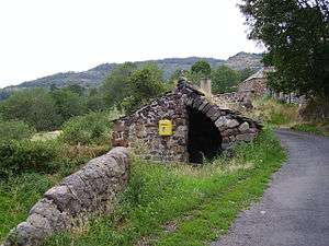
The hamlet of Serres in the town of Chanéac
See also
References
| Wikimedia Commons has media related to Chanéac. |
This article is issued from Wikipedia - version of the 10/28/2016. The text is available under the Creative Commons Attribution/Share Alike but additional terms may apply for the media files.