Intres, Ardèche
| Intres | |
|---|---|
|
Bridge over the Eyrieux | |
 Intres | |
|
Location within Auvergne-Rhône-Alpes region  Intres | |
| Coordinates: 44°59′01″N 4°21′48″E / 44.9836°N 4.3633°ECoordinates: 44°59′01″N 4°21′48″E / 44.9836°N 4.3633°E | |
| Country | France |
| Region | Auvergne-Rhône-Alpes |
| Department | Ardèche |
| Arrondissement | Tournon-sur-Rhône |
| Canton | Saint-Martin-de-Valamas |
| Government | |
| • Mayor (2008–2014) | Catherine Faure |
| Area1 | 10.05 km2 (3.88 sq mi) |
| Population (2008)2 | 116 |
| • Density | 12/km2 (30/sq mi) |
| Time zone | CET (UTC+1) |
| • Summer (DST) | CEST (UTC+2) |
| INSEE/Postal code | 07103 / 07320 |
| Elevation |
649–1,093 m (2,129–3,586 ft) (avg. 700 m or 2,300 ft) |
|
1 French Land Register data, which excludes lakes, ponds, glaciers > 1 km² (0.386 sq mi or 247 acres) and river estuaries. 2 Population without double counting: residents of multiple communes (e.g., students and military personnel) only counted once. | |
_Pont_sur_l'Eyrieux.JPG)
Intres is a commune in the Ardèche department in southern France.
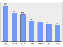
Population
| Historical population | ||
|---|---|---|
| Year | Pop. | ±% |
| 1962 | 249 | — |
| 1968 | 199 | −20.1% |
| 1975 | 188 | −5.5% |
| 1982 | 143 | −23.9% |
| 1990 | 136 | −4.9% |
| 1999 | 122 | −10.3% |
| 2008 | 116 | −4.9% |
See also
References
| Wikimedia Commons has media related to Intres, Ardèche. |
This article is issued from Wikipedia - version of the 10/28/2016. The text is available under the Creative Commons Attribution/Share Alike but additional terms may apply for the media files.