Pont-de-Labeaume
| Pont-de-Labeaume | |
|---|---|
|
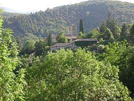
The church of Niègles, in Pont-de-Labeaume | |
 Pont-de-Labeaume | |
|
Location within Auvergne-Rhône-Alpes region  Pont-de-Labeaume | |
| Coordinates: 44°40′00″N 4°17′23″E / 44.6667°N 4.2897°ECoordinates: 44°40′00″N 4°17′23″E / 44.6667°N 4.2897°E | |
| Country | France |
| Region | Auvergne-Rhône-Alpes |
| Department | Ardèche |
| Arrondissement | Largentière |
| Canton | Thueyts |
| Government | |
| • Mayor (2008–2014) | Yves Verenc |
| Area1 | 4.66 km2 (1.80 sq mi) |
| Population (2008)2 | 577 |
| • Density | 120/km2 (320/sq mi) |
| Time zone | CET (UTC+1) |
| • Summer (DST) | CEST (UTC+2) |
| INSEE/Postal code | 07178 / 07380 |
| Elevation |
256–586 m (840–1,923 ft) (avg. 304 m or 997 ft) |
|
1 French Land Register data, which excludes lakes, ponds, glaciers > 1 km² (0.386 sq mi or 247 acres) and river estuaries. 2 Population without double counting: residents of multiple communes (e.g., students and military personnel) only counted once. | |
Pont-de-Labeaume is a commune in the Ardèche department in southern France.
Geography
The river Lignon forms small part of the commune's western border, then joins the Ardèche, which flows east through the commune.
The village is located in the western part of the commune, on the right bank of the Ardèche.
Population
| Historical population | ||
|---|---|---|
| Year | Pop. | ±% |
| 1962 | 465 | — |
| 1968 | 532 | +14.4% |
| 1975 | 545 | +2.4% |
| 1982 | 529 | −2.9% |
| 1990 | 517 | −2.3% |
| 1999 | 485 | −6.2% |
| 2008 | 577 | +19.0% |
See also
References
| Wikimedia Commons has media related to Pont-de-Labeaume. |
This article is issued from Wikipedia - version of the 2/11/2016. The text is available under the Creative Commons Attribution/Share Alike but additional terms may apply for the media files.