Thorrenc
| Thorrenc | |
|---|---|
|
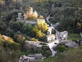
Thorrenc seen from the old railway viaduct | |
 Thorrenc | |
|
Location within Auvergne-Rhône-Alpes region  Thorrenc | |
| Coordinates: 45°14′14″N 4°45′47″E / 45.2372°N 4.7631°ECoordinates: 45°14′14″N 4°45′47″E / 45.2372°N 4.7631°E | |
| Country | France |
| Region | Auvergne-Rhône-Alpes |
| Department | Ardèche |
| Arrondissement | Tournon-sur-Rhône |
| Canton | Serrières |
| Intercommunality | Bassin d'Annonay |
| Government | |
| • Mayor (2008–2014) | Alain Zabal |
| Area1 | 3.67 km2 (1.42 sq mi) |
| Population (2008)2 | 232 |
| • Density | 63/km2 (160/sq mi) |
| Time zone | CET (UTC+1) |
| • Summer (DST) | CEST (UTC+2) |
| INSEE/Postal code | 07321 / 07340 |
| Elevation |
197–400 m (646–1,312 ft) (avg. 240 m or 790 ft) |
|
1 French Land Register data, which excludes lakes, ponds, glaciers > 1 km² (0.386 sq mi or 247 acres) and river estuaries. 2 Population without double counting: residents of multiple communes (e.g., students and military personnel) only counted once. | |
Thorrenc is a commune in the Ardèche department in southern France.
Population
| Historical population | ||
|---|---|---|
| Year | Pop. | ±% |
| 1962 | 100 | — |
| 1968 | 103 | +3.0% |
| 1975 | 84 | −18.4% |
| 1982 | 97 | +15.5% |
| 1990 | 152 | +56.7% |
| 1999 | 185 | +21.7% |
| 2008 | 232 | +25.4% |
See also
References
| Wikimedia Commons has media related to Thorrenc. |
I
This article is issued from Wikipedia - version of the 2/11/2016. The text is available under the Creative Commons Attribution/Share Alike but additional terms may apply for the media files.