Labastide-de-Virac
| Labastide-de-Virac | |
|---|---|
|
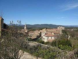
A general view of Labastide-de-Virac | |
 Labastide-de-Virac | |
|
Location within Auvergne-Rhône-Alpes region  Labastide-de-Virac | |
| Coordinates: 44°21′04″N 4°24′13″E / 44.3511°N 4.4036°ECoordinates: 44°21′04″N 4°24′13″E / 44.3511°N 4.4036°E | |
| Country | France |
| Region | Auvergne-Rhône-Alpes |
| Department | Ardèche |
| Arrondissement | Largentière |
| Canton | Vallon-Pont-d'Arc |
| Government | |
| • Mayor (2008–2014) | Jacques Marron |
| Area1 | 23.32 km2 (9.00 sq mi) |
| Population (2008)2 | 218 |
| • Density | 9.3/km2 (24/sq mi) |
| Time zone | CET (UTC+1) |
| • Summer (DST) | CEST (UTC+2) |
| INSEE/Postal code | 07113 / 07150 |
| Elevation |
40–408 m (131–1,339 ft) (avg. 260 m or 850 ft) |
|
1 French Land Register data, which excludes lakes, ponds, glaciers > 1 km² (0.386 sq mi or 247 acres) and river estuaries. 2 Population without double counting: residents of multiple communes (e.g., students and military personnel) only counted once. | |
Labastide-de-Virac is a commune in the Ardèche department in southern France
It features a small fort dating back to the 16th century.
Population
| Historical population | ||
|---|---|---|
| Year | Pop. | ±% |
| 1962 | 135 | — |
| 1968 | 145 | +7.4% |
| 1975 | 155 | +6.9% |
| 1982 | 184 | +18.7% |
| 1990 | 193 | +4.9% |
| 1999 | 218 | +13.0% |
| 2008 | 218 | +0.0% |
See also
References
| Wikimedia Commons has media related to Labastide-de-Virac. |
This article is issued from Wikipedia - version of the 10/28/2016. The text is available under the Creative Commons Attribution/Share Alike but additional terms may apply for the media files.