Boulieu-lès-Annonay
| Boulieu-lès-Annonay | ||
|---|---|---|
|
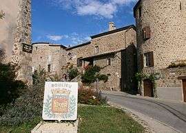
The road into Boulieu-lès-Annonay | ||
| ||
 Boulieu-lès-Annonay | ||
|
Location within Auvergne-Rhône-Alpes region  Boulieu-lès-Annonay | ||
| Coordinates: 45°16′18″N 4°40′02″E / 45.2717°N 4.6672°ECoordinates: 45°16′18″N 4°40′02″E / 45.2717°N 4.6672°E | ||
| Country | France | |
| Region | Auvergne-Rhône-Alpes | |
| Department | Ardèche | |
| Arrondissement | Tournon-sur-Rhône | |
| Canton | Annonay-Nord | |
| Intercommunality | Bassin d'Annonay | |
| Government | ||
| • Mayor (2008–2014) | Céline Bonnet | |
| Area1 | 9.45 km2 (3.65 sq mi) | |
| Population (2008)2 | 2,070 | |
| • Density | 220/km2 (570/sq mi) | |
| Time zone | CET (UTC+1) | |
| • Summer (DST) | CEST (UTC+2) | |
| INSEE/Postal code | 07041 / 07100 | |
| Elevation | 358–915 m (1,175–3,002 ft) | |
|
1 French Land Register data, which excludes lakes, ponds, glaciers > 1 km² (0.386 sq mi or 247 acres) and river estuaries. 2 Population without double counting: residents of multiple communes (e.g., students and military personnel) only counted once. | ||
.svg.png)
Boulieu-lès-Annonay is a commune in the Ardèche department in southern France.
See also
References
| Wikimedia Commons has media related to Boulieu-lès-Annonay. |
This article is issued from Wikipedia - version of the 10/28/2016. The text is available under the Creative Commons Attribution/Share Alike but additional terms may apply for the media files.