Saint-Sylvestre, Ardèche
| Saint-Sylvestre | |
|---|---|
|
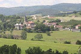
A general view of Saint-Sylvestre | |
 Saint-Sylvestre | |
|
Location within Auvergne-Rhône-Alpes region  Saint-Sylvestre | |
| Coordinates: 44°59′26″N 4°44′57″E / 44.9906°N 4.7492°ECoordinates: 44°59′26″N 4°44′57″E / 44.9906°N 4.7492°E | |
| Country | France |
| Region | Auvergne-Rhône-Alpes |
| Department | Ardèche |
| Arrondissement | Tournon-sur-Rhône |
| Canton | Saint-Péray |
| Intercommunality | Pays de Crussol |
| Government | |
| • Mayor (2008–2014) | Maurice Chantepy |
| Area1 | 15.16 km2 (5.85 sq mi) |
| Population (2008)2 | 475 |
| • Density | 31/km2 (81/sq mi) |
| Time zone | CET (UTC+1) |
| • Summer (DST) | CEST (UTC+2) |
| INSEE/Postal code | 07297 / 07440 |
| Elevation |
305–627 m (1,001–2,057 ft) (avg. 420 m or 1,380 ft) |
|
1 French Land Register data, which excludes lakes, ponds, glaciers > 1 km² (0.386 sq mi or 247 acres) and river estuaries. 2 Population without double counting: residents of multiple communes (e.g., students and military personnel) only counted once. | |
Saint-Sylvestre is a commune in the Ardèche department in southern France.
Population
| Historical population | ||
|---|---|---|
| Year | Pop. | ±% |
| 1793 | 850 | — |
| 1800 | 477 | −43.9% |
| 1806 | 572 | +19.9% |
| 1821 | 729 | +27.4% |
| 1831 | 662 | −9.2% |
| 1836 | 622 | −6.0% |
| 1841 | 716 | +15.1% |
| 1846 | 912 | +27.4% |
| 1851 | 930 | +2.0% |
| 1856 | 963 | +3.5% |
| 1861 | 977 | +1.5% |
| 1866 | 974 | −0.3% |
| 1872 | 925 | −5.0% |
| 1876 | 927 | +0.2% |
| 1881 | 845 | −8.8% |
| 1886 | 870 | +3.0% |
| 1891 | 869 | −0.1% |
| 1896 | 818 | −5.9% |
| 1901 | 783 | −4.3% |
| 1906 | 749 | −4.3% |
| 1911 | 660 | −11.9% |
| 1921 | 623 | −5.6% |
| 1926 | 581 | −6.7% |
| 1931 | 596 | +2.6% |
| 1936 | 548 | −8.1% |
| 1946 | 526 | −4.0% |
| 1954 | 486 | −7.6% |
| 1962 | 507 | +4.3% |
| 1968 | 475 | −6.3% |
| 1975 | 385 | −18.9% |
| 1982 | 363 | −5.7% |
| 1990 | 334 | −8.0% |
| 1999 | 350 | +4.8% |
| 2008 | 475 | +35.7% |
See also
References
| Wikimedia Commons has media related to Saint-Sylvestre, Ardèche. |
This article is issued from Wikipedia - version of the 10/28/2016. The text is available under the Creative Commons Attribution/Share Alike but additional terms may apply for the media files.