Beauchastel
| Beauchastel | |
|---|---|
|
A general view of Beauchastel | |
 Beauchastel | |
|
Location within Auvergne-Rhône-Alpes region  Beauchastel | |
| Coordinates: 44°49′36″N 4°48′14″E / 44.8267°N 4.8039°ECoordinates: 44°49′36″N 4°48′14″E / 44.8267°N 4.8039°E | |
| Country | France |
| Region | Auvergne-Rhône-Alpes |
| Department | Ardèche |
| Arrondissement | Privas |
| Canton | La Voulte-sur-Rhône |
| Intercommunality | Agglomeration Community of Privas Centre Ardèche |
| Government | |
| • Mayor (1995–2020) | Alain Valla |
| Area1 | 8.46 km2 (3.27 sq mi) |
| Population (2012)2 | 1,747 |
| • Density | 210/km2 (530/sq mi) |
| Time zone | CET (UTC+1) |
| • Summer (DST) | CEST (UTC+2) |
| INSEE/Postal code | 07027 / 07800 |
| Elevation |
96–560 m (315–1,837 ft) (avg. 100 m or 330 ft) |
|
1 French Land Register data, which excludes lakes, ponds, glaciers > 1 km² (0.386 sq mi or 247 acres) and river estuaries. 2 Population without double counting: residents of multiple communes (e.g., students and military personnel) only counted once. | |
Beauchastel is a French commune in the Ardèche department in the Auvergne-Rhône-Alpes region of southern France.[1]
The inhabitants of the commune are known as Beauchastellois or Beauchastelloises.[2]
Geography
Beauchastel is located some 10 km south by south-west of Valence and 20 km north-east of Privas. Access to the commune is by the D86 road from Charmes-sur-Rhône in the north which passes through the commune and continues south to La Voulte-sur-Rhône. The D86E branches from the D86 at the northern communal border and goes to the town then continues south to rejoin the D86 at La Voulte-sur-Rhône. The D21 goes west from the town to Saint-Laurent-du-Pape. The east of the commune includes a portion of the Île Saint-Thimé in the Rhône river which is also the departmental border with Drôme. A railway line from Saint-Péray in the north to La Voulte-sur-Rhône in the south passes through the commune but there is no station in the commune. The commune consists of a large urban area along the banks of the Rhône with farmland south of the Eyrieux and forested hills for the rest.[3][4]
A branch of the Rhône forms the eastern border of the commune with the main branch flowing south through the commune and continuing to eventually joining the sea at Port-Saint-Louis-du-Rhone. The Eyrieux river flows through the commune from the west to join the Rhône just south of the commune. Numerous streams rise in the commune and flow south to feed the Eyrieux including the Ruiseeau de Thouac (which forms the western border of the commune), the Ruisseau d'Abrou, and the Ruisseau de Chauvert. The Ruisseau de Feuillas flows east through the north of the commune to join the Rhône. There is a dam on the main branch of the Rhône with an electricity generating station: the Centrale Electrique de Beauchastel.[3][4] Beauchastel was often the victim of floods of the Eyrieux, until the construction of a damin the upper reaches of the river in 1860.
Mapping
A list of online mapping systems can be displayed by clicking on the coordinates (latitude and longitude) in the top right hand corner of this article.
Neighbouring communes and villages
 |
Gilhac-et-Bruzac | Saint-Georges-les-Bains | | |
| |
Étoile-sur-Rhône | |||
| ||||
| | ||||
| Saint-Laurent-du-Pape | La Voulte-sur-Rhône |
Toponymy
Beauchastel appears as Beauchaftel on the 1750 Cassini Map[5] and as Beauchastel on the 1790 version.[6]
History
The commune takes its name from the castle "Bel Castrum" built in the 12th century by the Lords of Retourtour and Briand. Since ravaged by the Wars of religion, all that remains is the fortified tower that dominates the village.
In the 17th and 18th century century Beauchastel was one of the Royal salt barns for the payment of the Gabelle of salt.
Administration
| From | To | Name | Party | Position |
|---|---|---|---|---|
| 1977 | 1995 | Henri Bouvier | ||
| 1995 | 2020[8] | Alain Valla |
(Not all data is known)
Demography
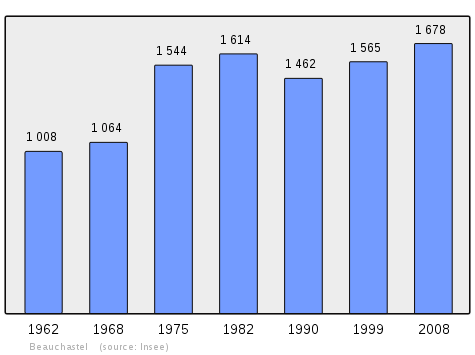
In 2012 the commune had 1,747 inhabitants. The evolution of the number of inhabitants is known from the population censuses conducted in the commune since 1793. From the 21st century, a census of communes with fewer than 10,000 inhabitants is held every five years, unlike larger communes that have a sample survey every year.[Note 1]
| 1793 | 1800 | 1806 | 1821 | 1831 | 1836 | 1841 | 1846 | 1851 |
|---|---|---|---|---|---|---|---|---|
| 578 | 487 | 569 | 678 | 817 | 847 | 866 | 840 | 840 |
| 1856 | 1861 | 1866 | 1872 | 1876 | 1881 | 1886 | 1891 | 1896 |
|---|---|---|---|---|---|---|---|---|
| 873 | 845 | 841 | 871 | 1,038 | 949 | 896 | 957 | 829 |
| 1901 | 1906 | 1911 | 1921 | 1926 | 1931 | 1936 | 1946 | 1954 |
|---|---|---|---|---|---|---|---|---|
| 796 | 789 | 763 | 807 | 910 | 856 | 840 | 801 | 863 |
| 1962 | 1968 | 1975 | 1982 | 1990 | 1999 | 2007 | 2012 | - |
|---|---|---|---|---|---|---|---|---|
| 1,008 | 1,064 | 1,544 | 1,614 | 1,462 | 1,565 | 1,709 | 1,747 | - |
Sources : Ldh/EHESS/Cassini until 1962, INSEE database from 1968 (population without double counting and municipal population from 2006)
Economy
- Tourism (medieval village)
- Fish Farming (Eyrieux valley)
- Hydroelectric plant (on a branch of the Rhône)
Local Culture and Heritage
Religious Heritage
- A Church from the 19th century
Sites and Monuments
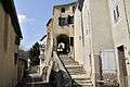
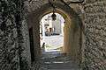
- The Bellum Castrum Medieval village. In 1179 the first lords, Retourtour and Briand, built a tower and ramparts to defend against invaders. The medieval village is built on the site of the old castle. During the Wars of religion the village was destroyed in 1622 by order of Louis XIII and the fortifications of Beauchastel were levelled; the ramparts and the defence towers disappeared. Despite these demolitions the site retained its medieval aspect enriched by architectural elements from the Renaissance until the early 20th century.
- The Ancient Castle dating back to the 12th century overlooks the village. It was limited to a protective Keep with a square base of which only a section of wall remains. It was destroyed together with the village during the wars of religion.
- A Church from the 18th century (1761).
- The Hydroelectric plant on the Rhone
Photo gallery
-
_vue_du_village.JPG)
View of the village
-
_ruelle_avec_%C3%A9glise.JPG)
Old village street and church
-
Rue de la grande porte
-
Entry to the village
-
_ruelle_en_escalier.JPG)
Old village: street and stairs
-

Calade
-
_mairie-%C3%A9cole.JPG)
The Town Hall/School
-
_monument_aux_morts.JPG)
The War memorial
-
_temple.JPG)
The Protestant Church
-
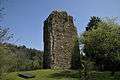
The remains of the Castle
See also
Notes and references
Notes
- ↑ At the beginning of the 21st century, the methods of identification have been modified by Law No. 2002-276 of 27 February 2002, the so-called "law of local democracy" and in particular Title V "census operations" allows, after a transitional period running from 2004 to 2008, the annual publication of the legal population of the different French administrative districts. For communes with a population greater than 10,000 inhabitants, a sample survey is conducted annually and the entire territory of these communes is taken into account at the end of the period of five years. The first "legal population" after 1999 under this new law came into force on 1 January 2009 and was based on the census of 2006.
References
- ↑ Beauchastel on Lion1906
- ↑ Inhabitants of Ardèche (French)
- 1 2 3 Beauchastel on Google Maps
- 1 2 Beauchastel on the Géoportail from National Geographic Institute (IGN) website (French)
- ↑ Beauchaftel on the 1750 Cassini Map
- ↑ Beauchastel on the 1790 Cassini Map
- ↑ List of Mayors of France (French)
- ↑ List of mayors of Ardèche, 24 April 2014, consulted on 29 July 2015 (French).
| Wikimedia Commons has media related to Beauchastel. |