Saint-Péray
For the French wine region, see Saint-Péray AOC.
| Saint-Péray | ||
|---|---|---|
|
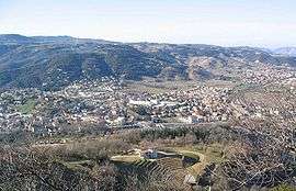
A general view of Saint-Péray | ||
| ||
 Saint-Péray | ||
|
Location within Auvergne-Rhône-Alpes region  Saint-Péray | ||
| Coordinates: 44°56′58″N 4°50′45″E / 44.9494°N 4.8458°ECoordinates: 44°56′58″N 4°50′45″E / 44.9494°N 4.8458°E | ||
| Country | France | |
| Region | Auvergne-Rhône-Alpes | |
| Department | Ardèche | |
| Arrondissement | Tournon-sur-Rhône | |
| Canton | Saint-Péray | |
| Intercommunality | Valence Major and Rhône Crussol | |
| Government | ||
| • Mayor (2008–2014) | Jean-Paul Lasbroas | |
| Area1 | 24.05 km2 (9.29 sq mi) | |
| Population (2008)2 | 7,268 | |
| • Density | 300/km2 (780/sq mi) | |
| Time zone | CET (UTC+1) | |
| • Summer (DST) | CEST (UTC+2) | |
| INSEE/Postal code | 07281 / 07130 | |
| Elevation |
107–652 m (351–2,139 ft) (avg. 128 m or 420 ft) | |
|
1 French Land Register data, which excludes lakes, ponds, glaciers > 1 km² (0.386 sq mi or 247 acres) and river estuaries. 2 Population without double counting: residents of multiple communes (e.g., students and military personnel) only counted once. | ||

Saint-Péray is a commune in the Ardèche department in the Auvergne-Rhône-Alpes region in southern France.
Population
| Historical population | ||
|---|---|---|
| Year | Pop. | ±% |
| 1793 | 1,559 | — |
| 1800 | 1,652 | +6.0% |
| 1806 | 1,528 | −7.5% |
| 1821 | 1,791 | +17.2% |
| 1831 | 2,321 | +29.6% |
| 1836 | 2,490 | +7.3% |
| 1841 | 2,485 | −0.2% |
| 1846 | 2,720 | +9.5% |
| 1851 | 2,584 | −5.0% |
| 1856 | 2,762 | +6.9% |
| 1861 | 2,680 | −3.0% |
| 1866 | 2,710 | +1.1% |
| 1872 | 2,521 | −7.0% |
| 1876 | 2,815 | +11.7% |
| 1881 | 2,658 | −5.6% |
| 1886 | 2,642 | −0.6% |
| 1891 | 2,555 | −3.3% |
| 1896 | 2,569 | +0.5% |
| 1901 | 2,603 | +1.3% |
| 1906 | 2,658 | +2.1% |
| 1911 | 2,587 | −2.7% |
| 1921 | 2,538 | −1.9% |
| 1926 | 2,595 | +2.2% |
| 1931 | 2,597 | +0.1% |
| 1936 | 2,634 | +1.4% |
| 1946 | 2,797 | +6.2% |
| 1954 | 3,168 | +13.3% |
| 1962 | 3,097 | −2.2% |
| 1968 | 3,592 | +16.0% |
| 1975 | 4,310 | +20.0% |
| 1982 | 5,196 | +20.6% |
| 1990 | 5,886 | +13.3% |
| 1999 | 6,502 | +10.5% |
| 2008 | 7,268 | +11.8% |
See also
- Château de Crussol, located on the territory of the commune.
- Communes of the Ardèche department
References
| Wikimedia Commons has media related to Saint-Péray. |
This article is issued from Wikipedia - version of the 10/28/2016. The text is available under the Creative Commons Attribution/Share Alike but additional terms may apply for the media files.