Dunière-sur-Eyrieux
| Dunière-sur-Eyrieux | |
|---|---|
|
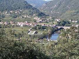
A general view of Dunière-sur-Eyrieux | |
 Dunière-sur-Eyrieux | |
|
Location within Auvergne-Rhône-Alpes region  Dunière-sur-Eyrieux | |
| Coordinates: 44°49′24″N 4°39′33″E / 44.8233°N 4.6592°ECoordinates: 44°49′24″N 4°39′33″E / 44.8233°N 4.6592°E | |
| Country | France |
| Region | Auvergne-Rhône-Alpes |
| Department | Ardèche |
| Arrondissement | Privas |
| Canton | Privas |
| Intercommunality | Eyrieux aux Serres |
| Government | |
| • Mayor (2008–2014) | Dominique Allain |
| Area1 | 7.73 km2 (2.98 sq mi) |
| Population (2008)2 | 392 |
| • Density | 51/km2 (130/sq mi) |
| Time zone | CET (UTC+1) |
| • Summer (DST) | CEST (UTC+2) |
| INSEE/Postal code | 07083 / 07360 |
| Elevation | 148–622 m (486–2,041 ft) |
|
1 French Land Register data, which excludes lakes, ponds, glaciers > 1 km² (0.386 sq mi or 247 acres) and river estuaries. 2 Population without double counting: residents of multiple communes (e.g., students and military personnel) only counted once. | |
Dunière-sur-Eyrieux is a commune in the Ardèche department in southern France.
The commune's name was changed from Dunières-sur-Eyrieux to Dunière-sur-Eyrieux (without "s") on 1 January 2001.[1]
Population
| Historical population | ||
|---|---|---|
| Year | Pop. | ±% |
| 1962 | 407 | — |
| 1968 | 430 | +5.7% |
| 1975 | 359 | −16.5% |
| 1982 | 324 | −9.7% |
| 1990 | 301 | −7.1% |
| 1999 | 324 | +7.6% |
| 2008 | 392 | +21.0% |
See also
References
| Wikimedia Commons has media related to Dunière-sur-Eyrieux. |
This article is issued from Wikipedia - version of the 10/28/2016. The text is available under the Creative Commons Attribution/Share Alike but additional terms may apply for the media files.