Gravières
| Gravières | ||
|---|---|---|
|
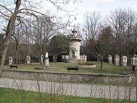
Sanctuary of Notre Dame de Lourdes | ||
| ||
 Gravières | ||
|
Location within Auvergne-Rhône-Alpes region  Gravières | ||
| Coordinates: 44°25′20″N 4°05′33″E / 44.4222°N 4.0925°ECoordinates: 44°25′20″N 4°05′33″E / 44.4222°N 4.0925°E | ||
| Country | France | |
| Region | Auvergne-Rhône-Alpes | |
| Department | Ardèche | |
| Arrondissement | Largentière | |
| Canton | Les Vans | |
| Intercommunality | Pays des Vans | |
| Government | ||
| • Mayor (2014–2020) | Monique Doladille | |
| Area1 | 18.52 km2 (7.15 sq mi) | |
| Population (2011)2 | 421 | |
| • Density | 23/km2 (59/sq mi) | |
| Time zone | CET (UTC+1) | |
| • Summer (DST) | CEST (UTC+2) | |
| INSEE/Postal code | 07100 / 07140 | |
| Elevation |
159–955 m (522–3,133 ft) (avg. 220 m or 720 ft) | |
|
1 French Land Register data, which excludes lakes, ponds, glaciers > 1 km² (0.386 sq mi or 247 acres) and river estuaries. 2 Population without double counting: residents of multiple communes (e.g., students and military personnel) only counted once. | ||
.svg.png)
Gravières is a commune in the Ardèche department in southern France.
Geography
The commune is traversed by the river Chassezac.
Population
| Historical population | ||
|---|---|---|
| Year | Pop. | ±% |
| 1793 | 1,033 | — |
| 1800 | 895 | −13.4% |
| 1806 | 936 | +4.6% |
| 1821 | 971 | +3.7% |
| 1831 | 1,034 | +6.5% |
| 1836 | 1,031 | −0.3% |
| 1841 | 1,052 | +2.0% |
| 1846 | 1,071 | +1.8% |
| 1851 | 1,093 | +2.1% |
| 1856 | 1,009 | −7.7% |
| 1861 | 955 | −5.4% |
| 1866 | 902 | −5.5% |
| 1872 | 864 | −4.2% |
| 1876 | 790 | −8.6% |
| 1881 | 737 | −6.7% |
| 1886 | 734 | −0.4% |
| 1891 | 736 | +0.3% |
| 1896 | 736 | +0.0% |
| 1901 | 677 | −8.0% |
| 1906 | 677 | +0.0% |
| 1911 | 611 | −9.7% |
| 1921 | 527 | −13.7% |
| 1926 | 535 | +1.5% |
| 1931 | 514 | −3.9% |
| 1936 | 492 | −4.3% |
| 1946 | 416 | −15.4% |
| 1954 | 420 | +1.0% |
| 1962 | 436 | +3.8% |
| 1968 | 459 | +5.3% |
| 1975 | 400 | −12.9% |
| 1982 | 381 | −4.7% |
| 1990 | 369 | −3.1% |
| 1999 | 370 | +0.3% |
| 2008 | 372 | +0.5% |
| 2011 | 421 | +13.2% |
See also
References
| Wikimedia Commons has media related to Gravières. |
This article is issued from Wikipedia - version of the 3/15/2016. The text is available under the Creative Commons Attribution/Share Alike but additional terms may apply for the media files.