Boucieu-le-Roi
| Boucieu-le-Roi | |
|---|---|
|
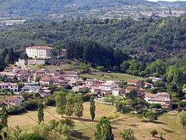
A general view of Boucieu-le-Roi | |
 Boucieu-le-Roi | |
|
Location within Auvergne-Rhône-Alpes region  Boucieu-le-Roi | |
| Coordinates: 45°02′12″N 4°40′58″E / 45.0367°N 4.6828°ECoordinates: 45°02′12″N 4°40′58″E / 45.0367°N 4.6828°E | |
| Country | France |
| Region | Auvergne-Rhône-Alpes |
| Department | Ardèche |
| Arrondissement | Tournon-sur-Rhône |
| Canton | Tournon-sur-Rhône |
| Intercommunality | Tournon |
| Government | |
| • Mayor (2008–2014) | Eric Banc |
| Area1 | 8.94 km2 (3.45 sq mi) |
| Population (2008)2 | 277 |
| • Density | 31/km2 (80/sq mi) |
| Time zone | CET (UTC+1) |
| • Summer (DST) | CEST (UTC+2) |
| INSEE/Postal code | 07040 / 07270 |
| Elevation |
242–623 m (794–2,044 ft) (avg. 276 m or 906 ft) |
|
1 French Land Register data, which excludes lakes, ponds, glaciers > 1 km² (0.386 sq mi or 247 acres) and river estuaries. 2 Population without double counting: residents of multiple communes (e.g., students and military personnel) only counted once. | |
Boucieu-le-Roi is a commune in the Ardèche department in southern France.
Population
| Historical population | ||
|---|---|---|
| Year | Pop. | ±% |
| 1962 | 357 | — |
| 1968 | 363 | +1.7% |
| 1975 | 287 | −20.9% |
| 1982 | 256 | −10.8% |
| 1990 | 277 | +8.2% |
| 1999 | 259 | −6.5% |
| 2009 | 279 | +7.7% |
See also
References
| Wikimedia Commons has media related to Boucieu-le-Roi. |
This article is issued from Wikipedia - version of the 10/28/2016. The text is available under the Creative Commons Attribution/Share Alike but additional terms may apply for the media files.