Beaulieu, Ardèche
For other uses, see Beaulieu.
| Beaulieu | ||
|---|---|---|
|
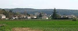
A panoramic view of Beaulieu | ||
| ||
 Beaulieu | ||
|
Location within Auvergne-Rhône-Alpes region  Beaulieu | ||
| Coordinates: 44°21′42″N 4°14′04″E / 44.3617°N 4.2344°ECoordinates: 44°21′42″N 4°14′04″E / 44.3617°N 4.2344°E | ||
| Country | France | |
| Region | Auvergne-Rhône-Alpes | |
| Department | Ardèche | |
| Arrondissement | Largentière | |
| Canton | Joyeuse | |
| Government | ||
| • Mayor (2008–2014) | Jean-François Borie | |
| Area1 | 25.47 km2 (9.83 sq mi) | |
| Population (2008)2 | 437 | |
| • Density | 17/km2 (44/sq mi) | |
| Time zone | CET (UTC+1) | |
| • Summer (DST) | CEST (UTC+2) | |
| INSEE/Postal code | 07028 / 07460 | |
| Elevation |
108–471 m (354–1,545 ft) (avg. 129 m or 423 ft) | |
|
1 French Land Register data, which excludes lakes, ponds, glaciers > 1 km² (0.386 sq mi or 247 acres) and river estuaries. 2 Population without double counting: residents of multiple communes (e.g., students and military personnel) only counted once. | ||
.svg.png)
Beaulieu (Occitan: Bèl Luòc) is a commune in the Ardèche department in southern France.
Population
| Historical population | ||
|---|---|---|
| Year | Pop. | ±% |
| 1962 | 384 | — |
| 1968 | 418 | +8.9% |
| 1975 | 417 | −0.2% |
| 1982 | 404 | −3.1% |
| 1990 | 373 | −7.7% |
| 1999 | 400 | +7.2% |
| 2008 | 437 | +9.3% |
See also
References
| Wikimedia Commons has media related to Beaulieu, Ardèche. |
This article is issued from Wikipedia - version of the 3/15/2016. The text is available under the Creative Commons Attribution/Share Alike but additional terms may apply for the media files.