Lussas
For the commune in the Dordogne department, see Lussas-et-Nontronneau.
| Lussas | |
|---|---|
|
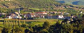
A general view of Lussas | |
 Lussas | |
|
Location within Auvergne-Rhône-Alpes region  Lussas | |
| Coordinates: 44°36′46″N 4°28′25″E / 44.6128°N 4.4736°ECoordinates: 44°36′46″N 4°28′25″E / 44.6128°N 4.4736°E | |
| Country | France |
| Region | Auvergne-Rhône-Alpes |
| Department | Ardèche |
| Arrondissement | Largentière |
| Canton | Le Teil |
| Intercommunality | Berg et Coiron |
| Government | |
| • Mayor (2008–2014) | Jean-Paul Roux |
| Area1 | 16.45 km2 (6.35 sq mi) |
| Population (2010)2 | 1,001 |
| • Density | 61/km2 (160/sq mi) |
| Time zone | CET (UTC+1) |
| • Summer (DST) | CEST (UTC+2) |
| INSEE/Postal code | 07145 / 07170 |
| Elevation |
199–632 m (653–2,073 ft) (avg. 270 m or 890 ft) |
|
1 French Land Register data, which excludes lakes, ponds, glaciers > 1 km² (0.386 sq mi or 247 acres) and river estuaries. 2 Population without double counting: residents of multiple communes (e.g., students and military personnel) only counted once. | |
Lussas is a commune in the Ardèche department in southern France.
Population
| Historical population | ||
|---|---|---|
| Year | Pop. | ±% |
| 1962 | 540 | — |
| 1968 | 561 | +3.9% |
| 1975 | 529 | −5.7% |
| 1982 | 585 | +10.6% |
| 1990 | 624 | +6.7% |
| 1999 | 776 | +24.4% |
| 2010 | 1,001 | +29.0% |
See also
References
| Wikimedia Commons has media related to Lussas. |
This article is issued from Wikipedia - version of the 10/28/2016. The text is available under the Creative Commons Attribution/Share Alike but additional terms may apply for the media files.