Le Lac-d'Issarlès
| Le Lac-d'Issarlès | |
|---|---|
|
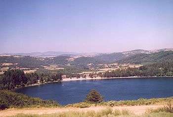
A general view of the Lac-d'Issarlès | |
 Le Lac-d'Issarlès | |
|
Location within Auvergne-Rhône-Alpes region  Le Lac-d'Issarlès | |
| Coordinates: 44°49′19″N 4°03′40″E / 44.8219°N 4.0611°ECoordinates: 44°49′19″N 4°03′40″E / 44.8219°N 4.0611°E | |
| Country | France |
| Region | Auvergne-Rhône-Alpes |
| Department | Ardèche |
| Arrondissement | Largentière |
| Canton | Coucouron |
| Government | |
| • Mayor (2008–2014) | Michel Gardes |
| Area1 | 14.35 km2 (5.54 sq mi) |
| Population (2008)2 | 270 |
| • Density | 19/km2 (49/sq mi) |
| Time zone | CET (UTC+1) |
| • Summer (DST) | CEST (UTC+2) |
| INSEE/Postal code | 07119 / 07470 |
| Elevation |
874–1,322 m (2,867–4,337 ft) (avg. 997 m or 3,271 ft) |
|
1 French Land Register data, which excludes lakes, ponds, glaciers > 1 km² (0.386 sq mi or 247 acres) and river estuaries. 2 Population without double counting: residents of multiple communes (e.g., students and military personnel) only counted once. | |
Le Lac-d'Issarlès is a commune in the Ardèche department in southern France.
Population
| Historical population | ||
|---|---|---|
| Year | Pop. | ±% |
| 1962 | 202 | — |
| 1968 | 253 | +25.2% |
| 1975 | 284 | +12.3% |
| 1982 | 290 | +2.1% |
| 1990 | 261 | −10.0% |
| 1999 | 253 | −3.1% |
| 2008 | 270 | +6.7% |
See also
References
| Wikimedia Commons has media related to Le Lac-d'Issarlès. |
This article is issued from Wikipedia - version of the 2/11/2016. The text is available under the Creative Commons Attribution/Share Alike but additional terms may apply for the media files.