Saint-Maurice-d'Ibie
| Saint-Maurice-d'Ibie | |
|---|---|
|
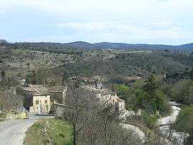
Saint-Maurice-d'Ibie, with the Ibie on the right | |
 Saint-Maurice-d'Ibie | |
|
Location within Auvergne-Rhône-Alpes region  Saint-Maurice-d'Ibie | |
| Coordinates: 44°30′07″N 4°29′01″E / 44.5019°N 4.4836°ECoordinates: 44°30′07″N 4°29′01″E / 44.5019°N 4.4836°E | |
| Country | France |
| Region | Auvergne-Rhône-Alpes |
| Department | Ardèche |
| Arrondissement | Largentière |
| Canton | Villeneuve-de-Berg |
| Intercommunality | Berg et Coiron |
| Government | |
| • Mayor (2008–2014) | Gérard Jaillon |
| Area1 | 23.3 km2 (9.0 sq mi) |
| Population (2008)2 | 201 |
| • Density | 8.6/km2 (22/sq mi) |
| Time zone | CET (UTC+1) |
| • Summer (DST) | CEST (UTC+2) |
| INSEE/Postal code | 07273 / 07170 |
| Elevation |
174–490 m (571–1,608 ft) (avg. 212 m or 696 ft) |
|
1 French Land Register data, which excludes lakes, ponds, glaciers > 1 km² (0.386 sq mi or 247 acres) and river estuaries. 2 Population without double counting: residents of multiple communes (e.g., students and military personnel) only counted once. | |
Saint-Maurice-d'Ibie is a commune in the Ardèche department in southern France.
Geography
The village lies in the north-western part of the commune, on the left bank of the river Ibie.
Population
| Historical population | ||
|---|---|---|
| Year | Pop. | ±% |
| 1962 | 119 | — |
| 1968 | 150 | +26.1% |
| 1975 | 159 | +6.0% |
| 1982 | 183 | +15.1% |
| 1990 | 163 | −10.9% |
| 1999 | 160 | −1.8% |
| 2008 | 201 | +25.6% |
See also
References
| Wikimedia Commons has media related to Saint-Maurice-d'Ibie. |
This article is issued from Wikipedia - version of the 10/28/2016. The text is available under the Creative Commons Attribution/Share Alike but additional terms may apply for the media files.